
Fukiware Falls: Plan the Riverside Walk Around the Open Paths
On this page
- Read the closure notice before choosing a circuit
- Choose the option that fits your day
- Understand the landscape you are coming to see
- Choose the rail-and-bus approach deliberately
- Arrive by car without confusing parking and admission
- Walk according to the markings beside the river
- Choose a season with the access in mind
- Give Oigami Onsen its own place in the day
- Use visual posts to understand the shape, not today's access
- Questions before you travel
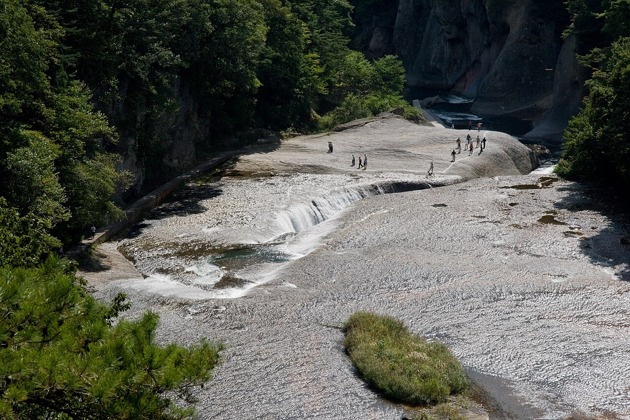

Fukiware Falls offers a strikingly different waterfall visit: the Katashina River runs across exposed rock and drops into a cleft beneath your viewing level. Start by checking the current path notices, then build the outing around the riverside section that is open. The mountain-side Takadoya path has been closed for investigation since November 6, 2026, while the city says the Okkai-side riverside path remains available. A complete loop should therefore stay out of your current plan.
Read the closure notice before choosing a circuit
The municipal notice is the starting point for this visit. Numata City states that the Takadoya-side, or mountain-side, walking path is closed until further notice for a safety investigation. It distinguishes that closure from the Okkai-side riverside path, which it describes as open as usual. Read the latest version before traveling because reopening information belongs to the operator, not an older itinerary.
This matters because general tourism introductions describe a broader walking circuit, with bridges, forest paths and viewpoints. Those introductions explain the landscape but do not override a dated closure. If a saved map shows a loop, mark the unavailable section and identify where your outward walk will turn back. A clear return on an open path is a better plan than reaching a barrier and improvising.
The viewing opportunity and the walking route are separate decisions. You may still be able to enjoy the falls while a longer circuit is unavailable, but you should choose the outing for the access actually offered. If the full loop is your main interest, wait for a confirmed reopening rather than treating a shorter visit as an equivalent experience.
Choose the option that fits your day
| Your situation | Useful choice | Check before committing |
|---|---|---|
| Main priority | Takadoya mountain-side path closed | Use the named station or current operator notice |
| Optional extension | Parking conditions vary | Choose the effort and availability separately |
| Comfortable finish | A confirmed bus or car return | Include the complete return journey |
Understand the landscape you are coming to see
Fukiware is not a conventional tall cascade seen from below. Water converges across a broad rocky riverbed and disappears into an eroded split. That creates the distinctive sense that the river is opening under itself. Look across the scene as well as down into the falling water; the shape of the rock and the movement of the current explain why this place looks so unusual.
The city describes a canyon shaped by erosion, with exposed walls and other formations along the Katashina River. You do not need a geology lesson to appreciate the visit, but noticing the relationship between the flat surfaces and the deep cuts makes the landscape more interesting than a single photograph. Stop at an approved viewing position and watch how separate streams join.
Different water conditions change the appearance. Official tourism information highlights the more forceful flow associated with spring snowmelt and the contrast of autumn foliage against rock and water. Choose the season that suits your trip rather than assuming every photograph shows the same conditions. High water also changes access decisions, so dramatic scenery is never a reason to ignore a closure.
Saylazy3 introduces a Fukiware Falls visit with photographs of the gorge. View original
Choose the rail-and-bus approach deliberately
Numata is the useful regional starting point for many public-transport visitors. The local tourism association describes buses from JR Numata Station toward Kamata, with a stop named Fukiware-no-taki. Check the current timetable, the exact stop name and the service for your date. The walk from the stop belongs in the plan along with the ride itself.
If you are arriving by Shinkansen through Jomo-Kogen, build that journey as a separate connection. Do not assume that a bus you found from Numata also serves the Shinkansen station in the same way. Compare the whole itinerary from your accommodation, including waiting time and the final return train, before deciding which rail station is more convenient.
Photograph or save the return timetable before entering the gorge. Decide which departure gives you enough time for the open riverside walk and a break, then keep a later service as a fallback only if one actually operates. An attractive walk becomes stressful when the group discovers that everyone has interpreted the last-bus time differently.
Soultiida de Cinema introduces the river landscape at Fukiware Falls in a 2020 film. View original
Arrive by car without confusing parking and admission
The city FAQ says there is no waterfall viewing charge, but parking arrangements vary. Some nearby parking areas are private businesses, and a sign saying that a place is close to the falls does not tell you its conditions. Read the terms where you park, including any fee or purchase requirement, and remember which entrance or stairway you used.
A car makes it easier to combine the falls with another stop in the region, but it does not remove the need to check the walking-path notice. Save the parking location and the current route map separately. The parking pin gets you to your vehicle; the visitor map tells you which paths are available once you leave it.
Keep larger bags in the car and carry what you need for the walk. Check the weather before descending into the riverside area, and give yourself enough time to return without hurrying. If one person is uncomfortable with the footing or the exposed setting, decide on a shorter shared visit rather than splitting up without a meeting point.
Walk according to the markings beside the river
Numata City's FAQ specifically warns that parts of the gorge do not have fences, and that the path near the falls can be narrow and slippery. Wear footwear with grip and follow the marked visitor side of the route. Look at the actual signs in front of you rather than copying where someone stood in a photograph.
When you stop, move to a suitable space before taking out your camera. Keep your attention on your footing while walking, particularly when another group is passing. A wide photograph from the visitor route often conveys the strange scale of the rock cleft better than leaning toward it. Children need close supervision in this setting, and every person should be comfortable with the path before continuing.
Leave any closed branch alone. If signs or staff direct you back the way you came, the turn-back point is part of the route rather than a puzzle to solve. Do not use an older bridge photograph as proof of an onward connection. Your aim is an enjoyable view of a working river landscape, with a straightforward return to the entrance.
Choose a season with the access in mind
The city's FAQ describes a usual winter closure from around mid-December to late March and states that the walking paths close at night. Those are useful seasonal expectations, but the specific opening and closure notices for your date are the deciding information. A winter photograph does not mean the riverside route is available beneath the snow.
Spring can bring strong water flow, while the tourism association highlights autumn colours in the gorge. Neither season has one fixed appearance. Rain, water levels and local work can alter the visit, so check both the forecast and the operator's notices before committing a long journey. If conditions are poor, a different regional stop can be a better use of the day.
Avoid building an evening arrival around the assumption that a natural attraction has no opening restrictions. The riverside paths are a daytime visit. Set your last viewing time early enough to walk back, locate the bus stop or car and continue onward comfortably. The gorge deserves your attention without a race against darkness.
Yutaka Nagai documents a 2016 gorge walk; paths shown belong to that older visit, separate from the current closure notice. View original
Give Oigami Onsen its own place in the day
The local tourism association suggests Oigami Onsen after the falls. That pairing can make a satisfying regional outing, but the hot-spring visit needs a named facility and its own access check. A hotel stay, a day-use bath and a stroll through an onsen district are different experiences with different requirements.
For public transport, confirm how the chosen bath or accommodation connects to the falls and your final station. Do not treat the distance between two map pins as a bus service. If you drive, save the facility's actual parking and arrival instructions. Give the bath enough time that it feels like a rest rather than a hurried addition before the last train.
If the falls are your only priority, finish with a simple meal near your chosen transport route instead. A smaller itinerary can work especially well when only part of the walking circuit is open. You can spend time watching the river and return in a relaxed way, without trying to compensate for a closed trail by adding more destinations.
Use visual posts to understand the shape, not today's access
Photographs and videos are particularly helpful here because the falls can be difficult to understand from a height figure alone. Compare a broad view with a closer view of the cleft and notice how the water moves across the rock. Older posts may show paths or viewpoints outside the present route, so keep the municipal closure notice beside the visual inspiration when planning.
Ch haiji describes a snowmelt-season visit and the water moving through the rock cleft. View original
Questions before you travel
Can I currently complete the usual walking loop?
The November 6, 2026 city notice closes the mountain-side Takadoya path until further notice and keeps the Okkai-side riverside path open. Plan an open-path visit and check the latest notice for any change before departing.
Is waterfall admission the same as parking?
No. The city lists waterfall viewing as free, while parking terms differ by parking area. Check the conditions of the specific place you use before leaving your car.
Is a winter visit the same riverside walk?
The usual winter closure affects the walking paths, and nighttime walking is also restricted. Read the actual seasonal notice and choose an available viewing option rather than expecting the ordinary river-level route throughout the year.