
Shasui Falls from Yamakita: Plan the Town Walk and Optional Viewpoint
On this page
- Start with the waterfall, then decide on the extra climb
- Choose the option that fits your day
- Reach Yamakita on the Gotemba Line
- Choose the station walk or the Hirayama bus connection
- Enjoy the shaded approach and the lower view
- Make the higher viewing route a deliberate choice
- Keep Kawamura Castle ruins as a separate walking decision
- Build a calm return through Yamakita
- Questions before setting off
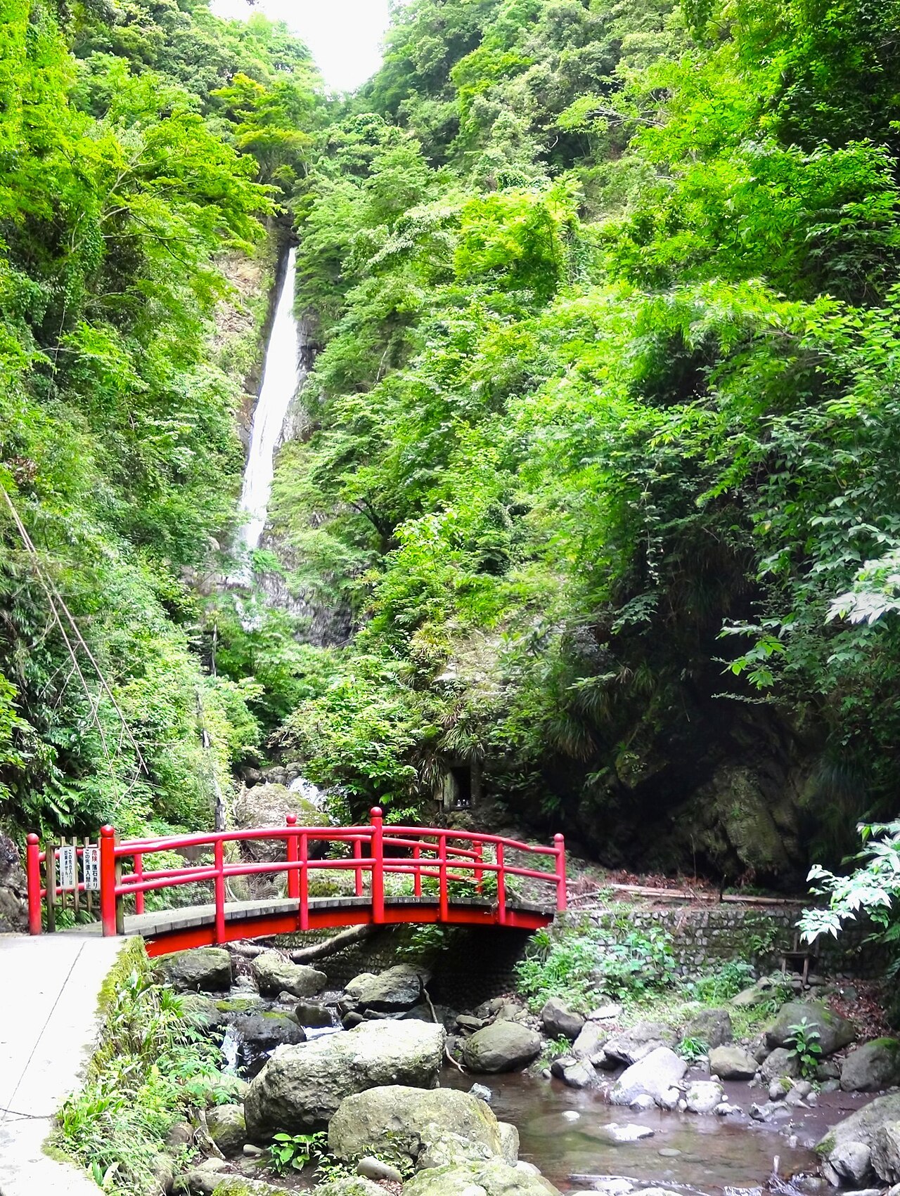

Use Yamakita Station as the starting point for a Shasui Falls outing, then decide whether to walk both ways or combine the visit with a local bus. The waterfall approach and the higher viewing route are separate choices. You can enjoy the wooded setting without turning the day into a longer hill walk, provided you plan the return through town and choose viewpoints that suit your group.
Start with the waterfall, then decide on the extra climb
Shasui Falls lies in the Hirayama area of Yamakita, in western Kanagawa. Its appeal is the contrast between a small-town approach and the shaded waterfall setting. For a first visit, give the falls a clear place in your day before adding other local walks. A route through town, a higher viewpoint and a separate historical site can feel close together on a map while asking for quite different amounts of energy.
The local tourism association describes viewing from the red bridge and a newer visitor path. It also states that the waterfall basin itself cannot be reached. Keep that distinction clear when looking at photographs: a close view of the falling water is not evidence that visitors may walk to its base. Follow the signs at the site and make the open public viewpoints the framework for your visit.
Decide in advance whether climbing to a higher outlook is a priority or an option. If one member of the group is uncertain about steps, start with a comfortable shared view and discuss the extra route there. An optional climb works better when everyone knows where it begins, where people will reunite and how it affects the rest of the outing.
Choose the option that fits your day
| Your situation | Useful choice | Check before committing |
|---|---|---|
| Choose your Yamakita approach | Save Gotemba Line connections | Compare walking with the local bus; Locate the visitor approach |
| Choose a comfortable view | Read the current visitor signs | Enjoy the shared lower outlook; Decide on the optional higher path |
| Keep the return clear | Reunite at a named place | Return through town or by bus; Reach the useful station connection |
Reach Yamakita on the Gotemba Line
Yamakita Station on the JR Gotemba Line is the useful rail reference. Plan your actual railway connections from your accommodation rather than assuming the waterfall is a central-Tokyo attraction. The final section of the rail journey, the local walk and the return are all part of the time you need for the outing.
Save a useful train for the return before leaving the station. You do not need to dictate every pause, but knowing the available services helps you decide whether a late lunch or an extra hill walk is realistic. If your journey uses more than one railway operator, keep the transfer locations and tickets clear. A convenient-looking line on a map can still involve a wait.
At Yamakita, orient yourself before walking away from the station area. Save the waterfall's Japanese name, 洒水の滝, and the visitor approach. The final characters describe a waterfall, but visually similar Japanese names can cause confusion when searching quickly. Use the named destination and the local tourism map together, especially if your phone offers several walking routes.
Japan Travel introduces Shasui as a Yamakita nature outing. View original
Choose the station walk or the Hirayama bus connection
The tourism association gives an approximate walking approach from Yamakita Station and also describes access from the Hirayama stop on the town's circulating bus. Treat these as alternatives to compare. A bus may reduce the town walk, while walking can give you more flexibility about departure time. Neither choice removes the need to plan how you will get back.
If using the bus, check its actual operating day, direction and stop location. A circular service can be less intuitive than a simple there-and-back route. Save the stop for the return and read the timetable rather than assuming a bus will arrive whenever you finish at the falls. If the timing is awkward, a planned station walk may be clearer than an uncertain wait.
For the walking option, examine the route as a real pedestrian journey through a lived-in town. Choose the signed approach, allow time at crossings and avoid treating a navigation shortcut as permission to cross private land. Agree on the pace before setting off. A group with children or someone who prefers regular rests should calculate the return with those same needs, instead of using a brisk adult estimate.
Enjoy the shaded approach and the lower view
As you reach the waterfall area, take a moment to read the signs before continuing. The local association identifies the red-bridge view as a way to appreciate the falls. This is a useful first destination: everyone can see the setting before deciding whether the additional path suits them. Take your first photographs from a position where you can stand comfortably and leave room for others.
The wooded surroundings change the feel of the outing after the town walk. Stop long enough to notice the water's movement, the height of the rock face and the way the trees frame the view. You do not need a complicated photographic technique to record that contrast. A wide composition can show the setting; a closer frame can concentrate on the falling water.
Keep the visitor boundary in mind even if an older photograph suggests a different route. The association says the basin is not accessible. A waterfall associated with spiritual practice is still a place where ordinary visitors should follow the current public route. Do not interpret a story about historical use of the water as an invitation to enter it.
Photo.by_tomo connects Shasui’s waterfall landscape with the higher observation route. View original
Make the higher viewing route a deliberate choice
The newer visitor path offers another way to experience the waterfall. Before beginning an extra climb, look at the route information and consider how everyone is feeling after the approach from Yamakita. A scenic destination can be modest in distance while still involving effort on steps. The return down also deserves attention.
If your group chooses to continue, keep bags compact and hands available. Stop at suitable places rather than trying to photograph while climbing. Give people coming the other way space and take any handrail or surface guidance seriously. The purpose of the ascent is a different view of the landscape, not a race to reach the highest available position.
If someone prefers to remain below, choose a precise reunion place and a sensible time to check in. Do not leave the agreement as “near the waterfall,” where several paths and viewpoints can make people hard to find. It may be simpler to stay together and skip the climb. A shared lower view followed by a relaxed return can be more enjoyable than an outing organised around the strongest walker.
Keep Kawamura Castle ruins as a separate walking decision
Yamakita's official walking material also connects the area with Kawamura Castle ruins. That can give a longer outing a historical theme, but it should be a conscious extension. A waterfall visit from the station and a hill walk to castle ruins are not the same route merely because they appear on one leaflet.
If the ruins are important to you, read the municipal walking map before the trip. Identify the access, any climbs and where the route joins the town journey. Decide whether to visit the waterfall or the historical area first, then work backward from the return train. Keep a shorter route available if the weather or the group's energy makes the full combination unattractive.
For a first visit focused on Shasui, the simplest choice is often to leave the ruins for another outing. This lets you pause at the waterfall and have a meal without feeling that you have omitted half the itinerary. Travellers who enjoy longer walking days can choose the combined route at the outset and prepare accordingly. The difference is planning the additional effort rather than discovering it halfway through.
Yudai._13 identifies Shasui Falls in the original post. View original
Build a calm return through Yamakita
Before leaving the waterfall area, check the time, your route and the next train or bus. If you walked out from the station, remember that the return is still part of the outing. A rest before departure can be useful, particularly if you have added the higher viewpoint. Keep food and water accessible, and collect any layers you removed on the approach.
A meal near the station can provide a good ending, but check the chosen business's hours and whether the railway timetable allows it. Do not assume that every shop in a small town opens continuously through the afternoon. If your main priority is catching a particular connection, make that journey first and place the meal where it fits comfortably.
For photographs, review your images after you have returned to a stable resting place. The combination of the town approach, forest and waterfall may tell the story better than many nearly identical close-ups. Choose a few images and keep the rest of the journey simple. A well-planned return helps this small excursion feel like a refreshing day out instead of a series of missed connections.
Questions before setting off
How do I choose between walking and the local bus?
Compare the pedestrian route with the bus operating day and departure times. Walking offers flexibility; the bus can reduce the town approach when its timetable fits. Plan the return at the same time.
Can I walk to the waterfall basin?
The local tourism association states that the basin cannot be reached. Use the open visitor viewpoints and follow the current signs.
Must I climb the newer viewing path?
Make it optional according to the route information and your group's comfort. Start with the shared lower view and decide whether another perspective is worth the effort.
Can I combine this with Kawamura Castle ruins?
Yes, as a separately planned walking extension using the municipal map. Include its hills and return journey rather than treating it as a quick detour.
What should I check on the morning of the visit?
Read local access notices, check the weather and save the current rail or bus services. Then choose the shorter or longer version of the outing to match the conditions and your companions.
Lady ExpressTV introduces Shasui Falls in a 2022 video. View original
Travel videos from All Japan
Popular YouTube posts
 4k hdr japan travel | Walk in Kamakura (鎌倉)Kanagawa Japan | Relaxing Natural City ambienceTravel at HomeYouTube · 1,347,114 views
 4k hdr japan travel 2024 | Walk in Kamakura(鎌倉)Kanagawa japan | Relaxing Natural City ambienceTravel at HomeYouTube · 1,150,604 views
 Nikko🇯🇵 Japan's Sacred Mountain World of Golden Shrines and Giant Cedars | 4KDuckTravel走鴨旅行YouTube · 812,249 views
 4k hdr japan travel 2024 | Walk in Kamakura(鎌倉)Kanagawa japan | Relaxing Natural City ambienceTravel at HomeYouTube · 342,792 views
 4K Japan Seaside Village Walk - Kamakura Enoden Train Line Kanagawa Suburbs Walking Tour | HDR 60fpsWorld Wanderings: 4K Walking ToursYouTube · 228,767 views
 4k hdr japan travel 2024 | Walk in Kamakura(鎌倉)Kanagawa japan | Relaxing Natural City ambienceTravel at HomeYouTube · 127,219 views
 Walking Forest Path, Akame 48 Falls in Autumn | Mie, JapanAmbient ExplorationYouTube · 108,364 views